

|
|
||||||||||||||
|
|
|
|
|
|
|
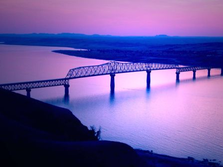
The Beginning of a "New Town" On January 1, 1951, our town was a stubble field with only one small building, located on what was to be Main Street. Many events preceded the signing of the Declaration of Independence, which marked the beginning of the United States of America. Many events and years had elapsed before that little building was moved on a stubble field to start our town. And this it how it began. Years ago when this land was opened for settlement there was flooding up and down the Missouri River every spring. Some of the floods were minor, but some years the loss of property and lives was colossal. During the drought of the thirties thoughts turned to the possibilities of using the water of the Missouri River for irrigation. In our area surveying crews did work up and down the River in the late thirties and early forties, but no information was given to the local people why the surveyors were here or the results of their findings. The talk of a dam on the Missouri River increased and the location of the dam was of much speculation. Most people were of the opinion that the dam would be in the Sanish or Garrison area, or some place in between the two towns. It was finally announced the dam would be at Garrison. This was one of several dams to constructed on the Missouri River, but the only one in North Dakota. In 1944 Congress authorized the Garrison Dam and Reservoir Project. A year of preparatory work followed and on October 4, 1946 the first shovel of dirt was turned on the excavation at the dam proper. The purpose of the dam was to provide flood control; to provide for irrigation; produce hydroelectric power; provide means of diversion eastward to the James and Sheyenne River basins; and to provide facilities for recreation and for fish and wildlife preservation. The dam was planned to be the world's largest rolled-earth filled dam and create the second largest reservoir in the world. This reservoir would form a lake 200 miles long, 14 miles wide at some points and have about 1,500 miles of shoreline. Those of us living in southern Mountrail County were aware that Sanish would have to be evacuated and relocated before the dam was completed. It was not until 1948 and early 1949 that people began to realize the extent of the lake that would be created by the dam. About this time the people of Van Hook learned that the southern part of their town would be under water, the railroad would have to be moved as well as the grain elevators and several major businesses. The Van Hook people realized that all the fertile farmland from the village to the Missouri River would be a lake and the town itself on a peninsula. This area was to be the widest part of the reservoir. Alarm gave way to study of the situation. Van Hook decided to send a delegation to Washington, D.C., to present their problem to Congress. Van Hook was requesting the government to buy all of the town , giving the people the same chance to relocate as was given to Sanish. The delegation met with Senator Young and Senator Langer and our Congressmen, as well as many other influential people. All were interested and concerned with Van Hook's problem. But of all the people contacted, Senator Young was the most sympathetic and helpful. His interest in our town continues to this day. The Van Hook delegation felt their initial mission was successful. Senator Young introduced a bill in Congress known as the Army Civil Functions Appropriation Bill HR 3734 which contained as one of its provisions that funds allocated to the Garrison Reservoir project may be expended for acquisition of any property within the incorporated village of Van Hook and the adjacent area known as Legion Park, North Dakota. This bill was approved by Congress and the Army Corps of Engineers in charge of the Garrison Dam project promised Van Hook all the help and support that was to be given to Sanish in relocating their town. Sanish had made no definite plans for relocating, but they had no alternative. Van Hook could move the part of the town to be inundated north of the village wherever the railroad was located and the rest of the town remain, but with a major part of the trade territory lost, this was not a favorable solution. The two towns had a common problem--where to move? Sanish had a population of not quite 500, and Van Hook's population was closer to 400. The idea of combining the towns gained popularity. With the combination of the assets of the two towns and the federal funds available, it would be possible to build a new, modern town with water and sewer facilities. One town would be better than two little villages similar to Van Hook and Sanish. Someone suggested the new town should be called Vanish after the two towns. Sanhook was also a suggestion. Finally it was decided to form a non-profit organization to carry out plans for the proposed town. This organization was called the Sanish-Van Hook Relocation Company. To provided funds for the immediate financial needs to carry out their plans for a town, ten men from Sanish and ten men for Van Hook each loaned the company one thousand dollars. When funds became available through the sale of lots and other revenue, these men were each repaid the thousand dollar loan. After the formation of this company the location of a new town site was of immediate concern. All agreed the new site must be in a fairly level area with possibilities for expansion, have a plentiful supply of water, easily accessible by roads from every direction, located on the railroad and be in a position close to the new bridge to be built across the reservoir. A total of seven possible sites were inspected before the present site was chosen. After the selection of the site the land was purchased for $75.00 an acre from Anna Wuttke of Minot. Following the purchase of this property, plans quickly were developed for the proposed town. Petitions were circulated in Sanish and Van Hook asking for relocation to the proposed site. This petition was signed by a large majority of the electors in both towns. On the basis of this petition the Army engineers promised to help plan the new town and assist the people with legal and engineering help. They agreed to plat the site, plan highways and streets and build them or finance the building of streets, alleys and sidewalks. By August 1950 the combined townsite was platted. On September 10, 1950, a groundbreaking ceremony and celebration was held at the proposed townsite. The official groundbreaking was furrow cut by a county road grader in what was to become Main Street. During this period the land acquisition division of the Corps of Engineers was appraising the properties in Sanish and Van Hook and the farms that would be inundated by the waters of the dam. At this time, too, surveyors were at work staking out the railroad route and relocating Highway 23. Also preliminary studies for the new bridge to be located across the reservoir south of Sanish were being made. With all this activity in the area it was an interesting place for tourist and local residents to visit. Signs along the way proclaimed "This way to the new town OR "This is the site of the new town to be made up of Van Hook and Sanish. Though in the early planning stages of the town it had been noted that the name of the new town was to be selected by its citizens--the name of the town was never proposed or voted on. It was known, at a new town in the beginning and in time became New Town to all. Following the platting of the townsite and its dedication, plans were made to sell lots. A small building was moved to the townsite and located on what was to be Main Street. This building became the office for the Sanish-Van Hook Relocation Co. It was from this office the lot sale was held. Members of the Relocation Co. conducted the lot sale, with the assistance of a Minot attorney. The sale of lots began on October 27, 1950. The first lot was sold to Mrs. Nora E. Lenartz and she also built the first home in New Town. The first two days of the lot sale over 60 percent of the lots were sold, which was very encouraging to the Relocation Co. The future residents of the new town were very enthusiastic, too. When the town was platted the location of the school was designated in the plans. It was a very, desirable location, centrally located. The school area was not sold, but presented as a gift to the school district. The congregations of the church of the various denominations in Van Hook and Sanish had been uniting and organizing as one congregation to carry on the work of the churches in New Town. Each church group was given the gift of a lot for their new church by the Relocation Co. Several elections were held to determine the wishes of the citizens of Sanish and Van Hook. The first election in 1951 was to decide whether or not the village governments of each town would be dissolved as of April 30, 1953. This passed by a great majority in both towns. Two weeks later another election was held and the electors voted, again by a decisive majority, to transfer the assets of both villages to the new town. In May 1951 the New Town Water and Sewer Utility Co. came into existence after much time, travel and effort by a committee of the Relocation Co. It was through the work of this group that a loan of $550,000 was obtained through the Reconstruction Finance Corporation. A third town, Elbowoods, had to move before the dam was completed. Elbowoods was the headquarters for the Bureau of Indian Affairs and the business offices of the Fort Berthold Reservation. It had a large school and two missionary churches, the Catholic and the Congregational. Officials of the Bureau of Indian Affairs and other government personnel met with representatives of the New Town group to discuss the possibility of locating in New Town. Both groups felt it would be an advantage for Elbowoods to move to New Town. In February 1952, the Fort Berthold Agency announced it was moving its headquarters to New Town. One little building, located on Main Street, was New Town on January 1, 1951. Construction of homes and businesses began later that year. Many homes and businesses were moved from Van Hook and Sanish and it was common sight to see a large building moving down the highway into town. Peter Brehm moved the first house into town and Nora Lenartz built the first home. Stockman's Bar, owned by Mabel and Joe Fitzpatrick, and was the first business, followed very quickly by Stephens Lumber Co. In November 1952, seventy-four voters went to the polls to elect the first city officials of New Town. On January 1, 1953, the post office was established in the former office of the Relocation Co. Hulbert Olson of Van Hook was the first postmaster. Businesses were moved from Van Hook and Sanish and soon the people left in the towns had to go to New Town for groceries and supplies. The towns were officially dissolved as of April 30, 1953, and July 1, 1953 was the deadline given the residents to be moved out of their respective towns. In the fall of 1953, school opened for New Town students. Grades 1, 2, 4 and 5 were in the Community Hall. Grade 3 in a rural schoolhouse moved near the hall. Grades 6 through 12 had classes in the school building at Sanish. Families provided their own transportation. The new school was ready in September 1954, and dedicated April 15, 1955. Enrollment was 432. The first scheduled train arrived at New Town September 22, 1953. School was dismissed at noon that day in order that everyone could join in the celebration. Senator Young drove the traditional golden spike to mark the completion of the railroad. By 1955 the town had grown to about 1,400 residents. The discovery of oil in our part of the state led to the development of oil fields in our vicinity. This brought many people into the community. Work on the new bridge, roads, and construction in the town with the drilling for oil made jobs plentiful. A major improvement to New Town during this period was the paving of the streets. This paving was a mixture of soil-cement for which the city had bonded itself for $138,000. The new bridge across the reservoir was completed and opened for travel in October 1955. It was named Four Bears after two great Indian chiefs, a Mandan and a Hidatsa, who bore the same name. Immediately following the dedication of the new bridge, the dismantling of the old Verendrye Bridge at Sanish was began. Elbowoods brought us Dr. Wilson, who later opened his own office, and still later set up the Health Center in a building provided by the community from sale of stock. Our city is located on State Highway 23 at the crossing of Lake Sakakawea by the Four Bears Bridge. We boast of having a recreation area for summer and winter fishing, boating, water skiing, and ice for snowmobiling and skating in winter. Summers offers trails for horseback riding, motorcycling, and hiking. There are cottage sites, camping facilities, a swimming pool, kiddies' playground, and a scenic nine-hole golf course--all within a three mile radius. Fishing here is mainly walleye and northern pike. There are pictures of many large fish caught in Lake Sakakawea. In the fall there is hunting of antelope and deer, grouse, partridge, pheasant, ducks, and geese. The businessmen, individuals, club--commercial, social, and service-- churches, and schools of the area have worked hard for many years in arranging for the accomplishments of our community and many tasks go without mention. The above article was taken from the book "NEW TOWN 1951-1976, written by James Mcmaster, editor of the New Town News in 1976.
|
||
|
|
||
| Site Map |